
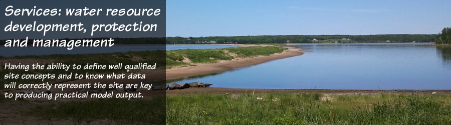
| Modelling environmental processes can give insight to support and expand upon professional concepts and scientific hypothesis, by quantitatively representing the essential features of actual groundwater systems and interaction with surface waters, with graphical 2-D and 3-D visualization that can directly benefit clients. Developing and applying complex groundwater and surface water models requires sound data and a firm understanding of the physics of the integrated hydrologic, geologic, and watershed landscape systems. For over 20 years, we have been modelling hydrologic systems across Atlantic Canada to meet regulatory requirements, to assess the safety of dams, and for water supply analysis. |
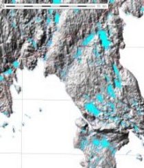
Groundwater flow modelling
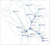
The visualization offered by today's computer software can help us to help you better understand the complex subsurface and surface processes that can affect your groundwater supply -- the kind of graphics and knowledge that, for example, can help you achieve the level of public support you may need to introduce land-use policies to protect your water supply.See more.
 Whether
the goal for doing computer groundwater flow simulations is to better
understand groundwater recharge and related land-use issues,
to optimize well location or spacing to reduce interference
within wellfields or with neighbouring wells, or to define an action
plan and response times to help guard against accidents that can
threaten water supply quality, earth-water Concepts inc. staff have the
skills to help you.
Whether
the goal for doing computer groundwater flow simulations is to better
understand groundwater recharge and related land-use issues,
to optimize well location or spacing to reduce interference
within wellfields or with neighbouring wells, or to define an action
plan and response times to help guard against accidents that can
threaten water supply quality, earth-water Concepts inc. staff have the
skills to help you.
As in any other computer activity, garbage-in gives garbage-out. That's why our clients have learned to value our ability to acquire and weed through the available surface, groundwater, and geologic data -- to assess if it can be used to produce practical modelling output -- reliable 2-D or 3-D groundwater flow simulations that water suppliers and water planners can learn from to make informed decisions about capital investments and the sustainability of their new or expanded groundwater supplies.
We can apply any number of Windows or Linux-based computer modelling codes, and prefer open-source code where we can access and confirm the adequacy of algorithms used -- for example: the US-EPA's WhAEM to delineate wellhead protection areas, IGW for real-time multi-scale 3-D modelling, or PMWIN to incorporate the world-wide acclaimed USGS MODFLOW code with various solute and heat transport models.
To reduce costs for our clients, we have developed an extensive geographic and geologic database, which we manage using the open-source GRASS geographic information system (GIS) for our day-to-day work. Having the same mapping capabilities as other GIS, GRASS was designed specifically to manage remote sensing data and natural resources information, and has several built-in watershed, surface water flow, and 2-D and 3-D groundwater modelling capabilities -- so we may more easily provide you with complete:
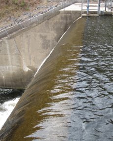
Dam safety analysis
In the face of ageing infrastructure and changing climate, most governments now recognize the need to ensure that our canals, reservoirs and dams remain structurally safe, and that their spillways are capable of handling increasing storm flows. It's important if we are to guard against potential harm to our homes, community properties, and water supplies.See more.
 Dam
safety reviews are done by multidisciplinary teams under direction of a
lead engineer. Critical components of these reviews are to assess the
affects that extreme rainfall/snowmelt events
may have on water levels behind dams, whether the structures are
designed to contain or properly control the resulting extreme flows,
and the extent and severity
of downstream flooding should they fail. These assessments are done by
computer simulation and earth-water Concepts inc. staff are
well versed at doing that kind of work. The tasks in which we can
contribute to multidisciplinary team efforts include:
Dam
safety reviews are done by multidisciplinary teams under direction of a
lead engineer. Critical components of these reviews are to assess the
affects that extreme rainfall/snowmelt events
may have on water levels behind dams, whether the structures are
designed to contain or properly control the resulting extreme flows,
and the extent and severity
of downstream flooding should they fail. These assessments are done by
computer simulation and earth-water Concepts inc. staff are
well versed at doing that kind of work. The tasks in which we can
contribute to multidisciplinary team efforts include:
The visualization offered by today's computer software can help us to help you better understand the complex subsurface and surface processes that can affect your groundwater supply -- the kind of graphics and knowledge that, for example, can help you achieve the level of public support you may need to introduce land-use policies to protect your water supply.See more.
Whether
the goal for doing computer groundwater flow simulations is to better
understand groundwater recharge and related land-use issues,
to optimize well location or spacing to reduce interference
within wellfields or with neighbouring wells, or to define an action
plan and response times to help guard against accidents that can
threaten water supply quality, earth-water Concepts inc. staff have the
skills to help you.As in any other computer activity, garbage-in gives garbage-out. That's why our clients have learned to value our ability to acquire and weed through the available surface, groundwater, and geologic data -- to assess if it can be used to produce practical modelling output -- reliable 2-D or 3-D groundwater flow simulations that water suppliers and water planners can learn from to make informed decisions about capital investments and the sustainability of their new or expanded groundwater supplies.
We can apply any number of Windows or Linux-based computer modelling codes, and prefer open-source code where we can access and confirm the adequacy of algorithms used -- for example: the US-EPA's WhAEM to delineate wellhead protection areas, IGW for real-time multi-scale 3-D modelling, or PMWIN to incorporate the world-wide acclaimed USGS MODFLOW code with various solute and heat transport models.
To reduce costs for our clients, we have developed an extensive geographic and geologic database, which we manage using the open-source GRASS geographic information system (GIS) for our day-to-day work. Having the same mapping capabilities as other GIS, GRASS was designed specifically to manage remote sensing data and natural resources information, and has several built-in watershed, surface water flow, and 2-D and 3-D groundwater modelling capabilities -- so we may more easily provide you with complete:
- aquifer characterization,
- groundwater quality and hydrochemistry assessments,
- wellfield site selection and design,
- wellfield optimization,
- wellhead and source water protection area delineation,
- pumping impact studies,
- contamination migration rate assessment and contingency planning for water supply protection,
- mine and other drainage impact analysis,
- regional water balance and groundwater recharge and discharge
studies,
- watershed modelling and analysis,
- conjunctive use evaluations.
Dam safety analysis
In the face of ageing infrastructure and changing climate, most governments now recognize the need to ensure that our canals, reservoirs and dams remain structurally safe, and that their spillways are capable of handling increasing storm flows. It's important if we are to guard against potential harm to our homes, community properties, and water supplies.See more.
Dam
safety reviews are done by multidisciplinary teams under direction of a
lead engineer. Critical components of these reviews are to assess the
affects that extreme rainfall/snowmelt events
may have on water levels behind dams, whether the structures are
designed to contain or properly control the resulting extreme flows,
and the extent and severity
of downstream flooding should they fail. These assessments are done by
computer simulation and earth-water Concepts inc. staff are
well versed at doing that kind of work. The tasks in which we can
contribute to multidisciplinary team efforts include: - calculating probable maximum precipitation, snowmelt, and probable maximum flows for the systems of interest,
- modelling watersheds and dams to assess changes in reservoir storage and water elevation resulting from maximum flows,
- assessing site geologic and hydrogeologic conditions regarding possible seepage within and groundwater flows beneath dams,
- flood mapping downstream of dams resulting from controlled releases and/or partial or total dam failure.
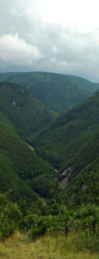
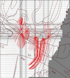
Watershed and surface water modelling
Rising rainfall intensity from climate change can cause reduced infiltration and increase storm-water runoff and soil erosion into rivers and lakes. This can directly impact water supplies, our homes as flood plains inundate more often, and our economy. This heightens the need to better understand and manage our watersheds and surface waters.See more.
 The
use of computers to simulate physical and chemical watershed and
streamflow processes is a cost effective way to define water supply
reservoir
requirements and to predict and plan for the affects that land-use and
rainfall changes may have on watershed systems and aquatic habitat. To
help define conditions and to hedge against costly mistakes that may
affect your investment. The
experienced staff at earth-water Concepts inc. can help you do just
that.
The
use of computers to simulate physical and chemical watershed and
streamflow processes is a cost effective way to define water supply
reservoir
requirements and to predict and plan for the affects that land-use and
rainfall changes may have on watershed systems and aquatic habitat. To
help define conditions and to hedge against costly mistakes that may
affect your investment. The
experienced staff at earth-water Concepts inc. can help you do just
that.
We are not engineers so we do not design dams or storm-water collection systems. But we have the skills and experience to understand how water works in the environment, and because our focus is to understand nature's science, we can report to clients without prejudice -- to work with municipalities, land owners, industry and engineers, for:
 In
addition to the built-in surface-flow, watershed and hydrologic
modelling capabilities of the GRASS-GIS that we use in our daily work,
a sampling of the software code we typically use to model
surface water includes HEC-HMS, HEC-RAS, HEC-ResSim and HEC-ResPRM to
model watersheds, streams, lakes and reservoirs, PRMS and GSFLOW to
simulate precipitation-runoff affects on surface water and groundwater,
HEC-EFM and HEC-FIA to
model flood effects and risks to ecosystems and communities, HSPF to
model
the affects of rainfall on soil erosion and non-point-source
contaminant
transport, and SWMM to simulate runoff in urban areas.
In
addition to the built-in surface-flow, watershed and hydrologic
modelling capabilities of the GRASS-GIS that we use in our daily work,
a sampling of the software code we typically use to model
surface water includes HEC-HMS, HEC-RAS, HEC-ResSim and HEC-ResPRM to
model watersheds, streams, lakes and reservoirs, PRMS and GSFLOW to
simulate precipitation-runoff affects on surface water and groundwater,
HEC-EFM and HEC-FIA to
model flood effects and risks to ecosystems and communities, HSPF to
model
the affects of rainfall on soil erosion and non-point-source
contaminant
transport, and SWMM to simulate runoff in urban areas.
Contaminant fate and transport modelling
The key to effective land and water resource management and protection is to avoid harmful chemical spills. But when that's not possible due to conflicting land use, learning where and how quickly contaminants are likely to move underground can help land owners, water suppliers and water-resource planners to assess levels of risk and how to respond.See more.
 Groundwater
computer models can help to assess rates of chemical dispersion,
mobility, and natural degradation in shallow and deep subsurface
aqueous environments. These models can serve as excellent tools to
help water resource managers assess levels of risk, emergency response
times, and to make decisions on best
management practices to protect existing or new water supplies, as well
as to protect streams that receive large amounts of their flow from
groundwater.
Groundwater
computer models can help to assess rates of chemical dispersion,
mobility, and natural degradation in shallow and deep subsurface
aqueous environments. These models can serve as excellent tools to
help water resource managers assess levels of risk, emergency response
times, and to make decisions on best
management practices to protect existing or new water supplies, as well
as to protect streams that receive large amounts of their flow from
groundwater.
Whether the goal is to define well placement scenarios to avoid drilling new wells where they may be exposed to impacts from past land use practices, to define source protection areas and response times as part of a new water resource management program, or to initiate aquifer remedial measures, the process of contaminant transport modelling must be done using good quality data, along with the correct set of skills and the experience to select the right computer code to ensure useful model output. The experienced staff at earth-water Concepts inc. have those skills.
We work cooperatively with communities, water suppliers and land owners to complete inventories of the point and non-point contamination sources within watersheds, then define source water and aquifer vulnerability using systematic processes and GIS for data management, before defining the most appropriate groundwater flow and contaminant transport computer code to use to simulate subsurface conditions. Proper data use and interpretation, for proper management of valuable water resources.
Rising rainfall intensity from climate change can cause reduced infiltration and increase storm-water runoff and soil erosion into rivers and lakes. This can directly impact water supplies, our homes as flood plains inundate more often, and our economy. This heightens the need to better understand and manage our watersheds and surface waters.See more.
The
use of computers to simulate physical and chemical watershed and
streamflow processes is a cost effective way to define water supply
reservoir
requirements and to predict and plan for the affects that land-use and
rainfall changes may have on watershed systems and aquatic habitat. To
help define conditions and to hedge against costly mistakes that may
affect your investment. The
experienced staff at earth-water Concepts inc. can help you do just
that.We are not engineers so we do not design dams or storm-water collection systems. But we have the skills and experience to understand how water works in the environment, and because our focus is to understand nature's science, we can report to clients without prejudice -- to work with municipalities, land owners, industry and engineers, for:
- precipitation modelling and watershed catchment analysis,
- watershed/local scale soil moisture accounting, water balances,
- watershed-scale and local-scale rainfall-runoff modelling,
- analysis of storm-run-off changes due to land use change,
- infiltration analysis for storm water flow reduction,
- storm event and continuous hydrologic simulations,
- surface water supply and hydro power reservoir storage analysis,
- reservoir and dam capacity modelling for severe rainfalls,
- reservoir system operations optimization,
- modelling ecosystem responses to changes in river flow regimes,
- landscape-scale erosion, nutrient, non-point-source pollution transport and stream-sediment-load modelling,
- watershed and stream-flow modelling for bridge-stream crossings,
- stream flood modelling, floodplain mapping, and analysis of flood damage potential.
In
addition to the built-in surface-flow, watershed and hydrologic
modelling capabilities of the GRASS-GIS that we use in our daily work,
a sampling of the software code we typically use to model
surface water includes HEC-HMS, HEC-RAS, HEC-ResSim and HEC-ResPRM to
model watersheds, streams, lakes and reservoirs, PRMS and GSFLOW to
simulate precipitation-runoff affects on surface water and groundwater,
HEC-EFM and HEC-FIA to
model flood effects and risks to ecosystems and communities, HSPF to
model
the affects of rainfall on soil erosion and non-point-source
contaminant
transport, and SWMM to simulate runoff in urban areas.
Contaminant fate and transport modelling
The key to effective land and water resource management and protection is to avoid harmful chemical spills. But when that's not possible due to conflicting land use, learning where and how quickly contaminants are likely to move underground can help land owners, water suppliers and water-resource planners to assess levels of risk and how to respond.See more.
Whether the goal is to define well placement scenarios to avoid drilling new wells where they may be exposed to impacts from past land use practices, to define source protection areas and response times as part of a new water resource management program, or to initiate aquifer remedial measures, the process of contaminant transport modelling must be done using good quality data, along with the correct set of skills and the experience to select the right computer code to ensure useful model output. The experienced staff at earth-water Concepts inc. have those skills.
We work cooperatively with communities, water suppliers and land owners to complete inventories of the point and non-point contamination sources within watersheds, then define source water and aquifer vulnerability using systematic processes and GIS for data management, before defining the most appropriate groundwater flow and contaminant transport computer code to use to simulate subsurface conditions. Proper data use and interpretation, for proper management of valuable water resources.

