
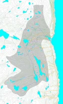
Isaacs Harbour River Watershed
earth-water Concepts inc. was hired to conduct a regional study on Nova Scotia's Eastern Shore for a 76,800 m3/d (20.3 million US gpd) water supply for a petrochemical plant, an LNG receiving terminal, and a 200 MW power plant. The site is in a rural area where shallow wells dug into clayey glacial tills are the local source of water for residences and small industry.
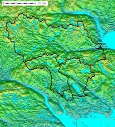 The study involved doing assessments of four watersheds that are 900, 7745, 8340 and 32460
hectares in size. Each watershed discharges via well developed drainage systems
into the Atlantic Ocean. The larger watershed drains to the east and is
underlain by relatively well drained soils and permeable sandstone. The
other watersheds are situated topographically below the larger one. They
drain to the south and have a thin glacial till cover over impermeable
metamorphosed sediments that also form the basement bedrock complex beneath the
sandstone units present below at the larger watershed. Major faults, some with several
kilometres of lateral displacement along them, which are present within the metamorphosed sediments,
are believed to also extend beneath the highly permeable sandstone horizons present at the larger
watershed.
The study involved doing assessments of four watersheds that are 900, 7745, 8340 and 32460
hectares in size. Each watershed discharges via well developed drainage systems
into the Atlantic Ocean. The larger watershed drains to the east and is
underlain by relatively well drained soils and permeable sandstone. The
other watersheds are situated topographically below the larger one. They
drain to the south and have a thin glacial till cover over impermeable
metamorphosed sediments that also form the basement bedrock complex beneath the
sandstone units present below at the larger watershed. Major faults, some with several
kilometres of lateral displacement along them, which are present within the metamorphosed sediments,
are believed to also extend beneath the highly permeable sandstone horizons present at the larger
watershed.
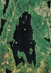
The 7745 hectare Isaacs Harbour River watershed and the 900 hectare Goldbrook sub-watershed were identified as the primary water source and possible short-term backup water source candidates, respectively, based on proximity to the plant site and availability of lakes that could be made to serve as reservoirs. earth-water Concepts inc. performed a comprehensive investigation of those two watersheds that:
Chester water supply options
The village of Chester, Nova Scotia, is a coastal community of about 2,000 people that has a central sewage collection and treatment system, but where individual water wells service its residents and businesses. Many of the water supplies consist of shallow dug wells with a history of going dry each summer. There was concern about the possibility that groundwater might be draining through the backfill in the sewer-line trenches. There was concern also about possible decreases in groundwater recharge as a result of climate change, and that the number or wells going dry, and the duration of the summer water shortages, could increase.

Earlier groundwater work done by earth-water Concepts inc. suggested that wells drilled into the local meta-sedimentary bedrock aquifer could meet water demand, but that significant iron concentrations were likely to require treatment. A lake situated in a relatively pristine watershed, and within a reasonable distance of the village, was thought also to maybe being able to serve as a water source to meet village demand. earth-water Concepts inc. was hired to perform a study that:
earth-water Concepts inc. was hired to conduct a regional study on Nova Scotia's Eastern Shore for a 76,800 m3/d (20.3 million US gpd) water supply for a petrochemical plant, an LNG receiving terminal, and a 200 MW power plant. The site is in a rural area where shallow wells dug into clayey glacial tills are the local source of water for residences and small industry.
The study involved doing assessments of four watersheds that are 900, 7745, 8340 and 32460
hectares in size. Each watershed discharges via well developed drainage systems
into the Atlantic Ocean. The larger watershed drains to the east and is
underlain by relatively well drained soils and permeable sandstone. The
other watersheds are situated topographically below the larger one. They
drain to the south and have a thin glacial till cover over impermeable
metamorphosed sediments that also form the basement bedrock complex beneath the
sandstone units present below at the larger watershed. Major faults, some with several
kilometres of lateral displacement along them, which are present within the metamorphosed sediments,
are believed to also extend beneath the highly permeable sandstone horizons present at the larger
watershed.The 7745 hectare Isaacs Harbour River watershed and the 900 hectare Goldbrook sub-watershed were identified as the primary water source and possible short-term backup water source candidates, respectively, based on proximity to the plant site and availability of lakes that could be made to serve as reservoirs. earth-water Concepts inc. performed a comprehensive investigation of those two watersheds that:
- included installation of rain gauges on the coast and
inland where precipitation data was missing, and installation of four
stream gauges to record continuous streamflows for 20 months,
- included large-scale GIS precipitation modelling based on field and government supplied data,
- characterized water balances and capacity for the subject watersheds, defined reservoir requirements, and identified preliminary criteria for water taking, dam design, and fish way design,
- identified river discharge surplus within the major watershed, defined flash flow versus base flow, and identified contributions to river discharge via groundwater sub-flow from the northern watershed as a result of flows along the regional bedrock faults,
- formed the basis for doing range of variability determinations for ecological stream flow maintenance and for water taking permits.
Chester water supply options
The village of Chester, Nova Scotia, is a coastal community of about 2,000 people that has a central sewage collection and treatment system, but where individual water wells service its residents and businesses. Many of the water supplies consist of shallow dug wells with a history of going dry each summer. There was concern about the possibility that groundwater might be draining through the backfill in the sewer-line trenches. There was concern also about possible decreases in groundwater recharge as a result of climate change, and that the number or wells going dry, and the duration of the summer water shortages, could increase.
Earlier groundwater work done by earth-water Concepts inc. suggested that wells drilled into the local meta-sedimentary bedrock aquifer could meet water demand, but that significant iron concentrations were likely to require treatment. A lake situated in a relatively pristine watershed, and within a reasonable distance of the village, was thought also to maybe being able to serve as a water source to meet village demand. earth-water Concepts inc. was hired to perform a study that:
- monitored groundwater levels in drilled and dug wells located within village boundaries,
- defined the effects that the sewer collection-system trenches may have had on groundwater using 3-D mapping of the local sewer systems, local aquifer, along with 3-D groundwater modelling,
- characterized the nearby watershed capacity and water quality through a comprehensive water sampling program and installation of lake level and stream gauging stations,
- systematically evaluated the groundwater and surface water supply options,
- defined water taking allocations, reservoir design requirements, and water permitting requirements for the surface water source, and
- served as the basis to make land purchases needed for protection
of the watershed and installation of water production infrastructure.
Town of Yarmouth reservoir
 The Town of Yarmouth wanted to evaluate their surface water supply
reservoir before doing reconstruction work on an existing earth and
concrete dam. earth-water Concepts inc. was hired by the municipality's
civil engineering firm to define total watershed capability, the
ability of the storage reservoir to meet existing demand, storage
requirements to meet future demand, and to do an overall water balance
to
help confirm estimates of withdrawals from the lake. Curiously enough,
while originally not a part of the project, the water balance
calculated as part of the assessment
identified a significant difference between water flowing into and out
of the
watershed and reservoir system, which, eventually, was accounted for
following the discovery of large
underground pipe leaks in the town's water distribution system.
The Town of Yarmouth wanted to evaluate their surface water supply
reservoir before doing reconstruction work on an existing earth and
concrete dam. earth-water Concepts inc. was hired by the municipality's
civil engineering firm to define total watershed capability, the
ability of the storage reservoir to meet existing demand, storage
requirements to meet future demand, and to do an overall water balance
to
help confirm estimates of withdrawals from the lake. Curiously enough,
while originally not a part of the project, the water balance
calculated as part of the assessment
identified a significant difference between water flowing into and out
of the
watershed and reservoir system, which, eventually, was accounted for
following the discovery of large
underground pipe leaks in the town's water distribution system.
Sherwood golf course expansion
The Sherwood Golf Course is a private course located on the south shore of Nova Scotia. The site is situated within a granite batholith terrain where fracture flow is the only form of aquifer permeability, and where soils are generally thin, offering very little available groundwater storage.
 The
owner was considering making an expansion to the golf course. But
first, he wanted to
assess the ability of the site to provide water for irrigation of the
existing and additional golf course areas. He also wanted to assess the
ability to design the golf course expansion in a way that would not
interfere with
water source development, but instead, to develop the addition to the
golf course that would enhance the ability to obtain and preserve water
supply. earth-water Concepts
inc. was hired to conduct a study of the local watershed that evaluated:
The
owner was considering making an expansion to the golf course. But
first, he wanted to
assess the ability of the site to provide water for irrigation of the
existing and additional golf course areas. He also wanted to assess the
ability to design the golf course expansion in a way that would not
interfere with
water source development, but instead, to develop the addition to the
golf course that would enhance the ability to obtain and preserve water
supply. earth-water Concepts
inc. was hired to conduct a study of the local watershed that evaluated:
Guysborough hydro project
earth-water Concepts inc. was hired to conduct a regional surface water study in northern Nova Scotia. The purpose of the study is to investigate water resources in the area and to find and help develop a water source to support a proposed hydro-electric project. The intent of the project was to sell power to market, and to carry out research on new water turbine technologies.
 There were no gauged watersheds nearby, so in order to move forward
with this project, it was necessary to install a number of stream
gauges at key locations within the watershed system. The purpose of the
study was to evaluate: total annual
availability of water within the subject watershed and at other gauged
watersheds where more continuous data could be extracted; define
seasonal and
longer-term variability of supply from the subject watershed, and
define seasonal variability of flows
possibly available for power generation; define the amount of reservoir
storage needed to
reduce seasonal variability in water volumes and flows; carry out
terrain and
slope analysis to identify the best locations for water taking for
power generating; and define water taking and reservoir
management criteria and schedules in order to maintain ecological
systems at the reservoir, at the water taking location, and downstream
of the water taking and power
generating facility.
There were no gauged watersheds nearby, so in order to move forward
with this project, it was necessary to install a number of stream
gauges at key locations within the watershed system. The purpose of the
study was to evaluate: total annual
availability of water within the subject watershed and at other gauged
watersheds where more continuous data could be extracted; define
seasonal and
longer-term variability of supply from the subject watershed, and
define seasonal variability of flows
possibly available for power generation; define the amount of reservoir
storage needed to
reduce seasonal variability in water volumes and flows; carry out
terrain and
slope analysis to identify the best locations for water taking for
power generating; and define water taking and reservoir
management criteria and schedules in order to maintain ecological
systems at the reservoir, at the water taking location, and downstream
of the water taking and power
generating facility.
The Town of Yarmouth wanted to evaluate their surface water supply
reservoir before doing reconstruction work on an existing earth and
concrete dam. earth-water Concepts inc. was hired by the municipality's
civil engineering firm to define total watershed capability, the
ability of the storage reservoir to meet existing demand, storage
requirements to meet future demand, and to do an overall water balance
to
help confirm estimates of withdrawals from the lake. Curiously enough,
while originally not a part of the project, the water balance
calculated as part of the assessment
identified a significant difference between water flowing into and out
of the
watershed and reservoir system, which, eventually, was accounted for
following the discovery of large
underground pipe leaks in the town's water distribution system.Sherwood golf course expansion
The Sherwood Golf Course is a private course located on the south shore of Nova Scotia. The site is situated within a granite batholith terrain where fracture flow is the only form of aquifer permeability, and where soils are generally thin, offering very little available groundwater storage.
The
owner was considering making an expansion to the golf course. But
first, he wanted to
assess the ability of the site to provide water for irrigation of the
existing and additional golf course areas. He also wanted to assess the
ability to design the golf course expansion in a way that would not
interfere with
water source development, but instead, to develop the addition to the
golf course that would enhance the ability to obtain and preserve water
supply. earth-water Concepts
inc. was hired to conduct a study of the local watershed that evaluated:- the total amount of water falling onto the watershed, as well as the total amount of water that might be available as a groundwater source and which could be properly permitted for withdrawal,
- natural and enhanced groundwater recharge potential, as well as total natural and well discharge from the watershed and aquifer,
- well yield potentials within the golf course areas, and
- possible surface water and groundwater interactions.
Guysborough hydro project
earth-water Concepts inc. was hired to conduct a regional surface water study in northern Nova Scotia. The purpose of the study is to investigate water resources in the area and to find and help develop a water source to support a proposed hydro-electric project. The intent of the project was to sell power to market, and to carry out research on new water turbine technologies.
There were no gauged watersheds nearby, so in order to move forward
with this project, it was necessary to install a number of stream
gauges at key locations within the watershed system. The purpose of the
study was to evaluate: total annual
availability of water within the subject watershed and at other gauged
watersheds where more continuous data could be extracted; define
seasonal and
longer-term variability of supply from the subject watershed, and
define seasonal variability of flows
possibly available for power generation; define the amount of reservoir
storage needed to
reduce seasonal variability in water volumes and flows; carry out
terrain and
slope analysis to identify the best locations for water taking for
power generating; and define water taking and reservoir
management criteria and schedules in order to maintain ecological
systems at the reservoir, at the water taking location, and downstream
of the water taking and power
generating facility.
